
Snowbird Driving From British Columbia to Baja 2026: The I-5 Route and Mexican Insurance

By Scott Tobin · · 12 min read
Last updated:
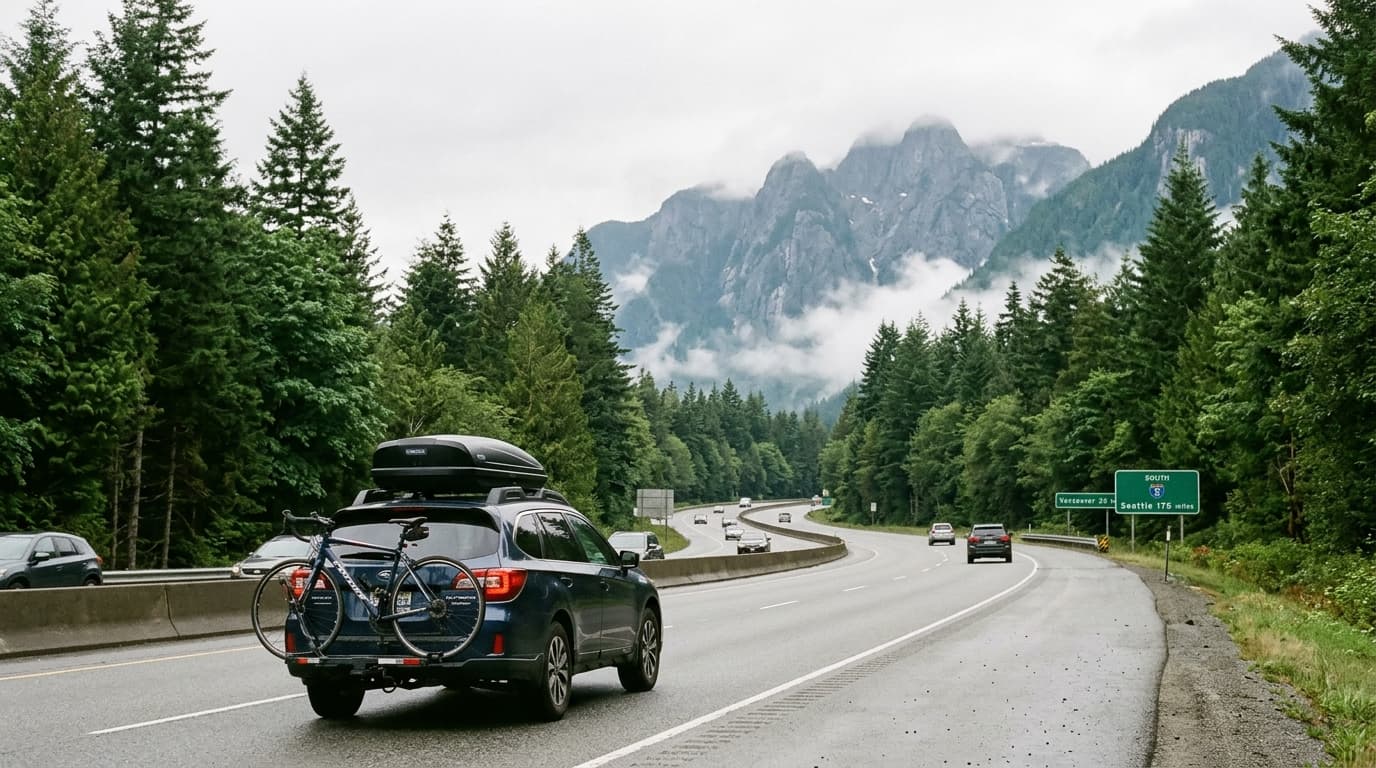
British Columbia has the easiest drive to Mexico of any Canadian province. Vancouver to the Tijuana border is roughly 1,600 miles, and essentially all of it is I-5 — one interstate, straight south, through Washington, Oregon, and California to San Diego. Three days at a comfortable pace.
Compared to the Alberta run through the Rockies, it's a milder trip in almost every respect: lower elevation, more predictable winter weather, and continuous services the whole way. It's a large part of why BC produces so many driving snowbirds.
The insurance answer is simple and worth getting right: if you're staying on the Baja peninsula, buy a Baja Only annual. It's the cheapest coverage that actually works, and a lot of BC drivers overpay for Nationwide they never use.
Your BC insurance does not cover Mexico
ICBC coverage, and any Canadian policy, stops at the Mexican border. Mexican federal law requires liability coverage from a Mexican-licensed insurer, and it's enforced at accident scenes and traffic stops. This is not a fine-print claims-handling issue — driving in Mexico on Canadian coverage alone means driving uninsured under Mexican law.
Some Canadian insurers sell Mexico extensions. Read them closely. They're typically supplemental physical-damage coverage that does not satisfy the Mexican liability requirement on its own.
Baja Only vs Nationwide
Baja Only covers the entire peninsula — Baja California and Baja California Sur, Tijuana all the way to Cabo San Lucas. Roughly $300-350 annually for a mid-value vehicle with full coverage.
Nationwide covers all of Mexico. Roughly $400-500 annually.
If your winter is a Baja winter, Baja Only is the correct product. You can base in Rosarito, spend February in Todos Santos, and drive to Cabo without changing anything.
Buy Nationwide only if you have real mainland plans — the La Paz to Mazatlán ferry, or a drive around through Sonora. Decide before you buy.
The free zone advantage
The Baja peninsula is a free zone: no Temporary Vehicle Import Permit required. No Banjercito deposit, no permit to cancel on the way home, no risk of forfeiting money because you drove north without stopping.
Mainland Mexico requires all of that. It's the single biggest practical reason west-coast Canadians default to Baja.
You do need an FMM tourist permit for a season-length stay. Get it at the crossing, confirm the dates granted, and keep it with your passport.
The route: I-5, essentially the whole way
Vancouver → Seattle. Cross at Peace Arch or Pacific Highway (Blaine). About 140 miles. Border waits vary; the Peace Arch crossing can be slow on weekends and holidays, and Pacific Highway is often quicker.
Seattle → Portland. About 175 miles, straightforward interstate.
Portland → Medford / Ashland. About 275 miles. This is the section that includes the mountain driving.
Medford → Sacramento / Redding. About 300 miles down through the Siskiyous and into the Central Valley.
Sacramento → Los Angeles. About 385 miles. I-5 through the valley is fast, dull, and efficient. The Grapevine (Tejon Pass) north of LA is the last elevation of the trip.
Los Angeles → San Ysidro / Otay Mesa. About 140 miles.
Total: roughly 1,600 miles from Vancouver. Three days is comfortable, two is possible if you're determined, four is relaxed.
The Grants Pass / Siskiyou question
I-5 is generally passable year-round, which is the corridor's main advantage. The exception is the stretch through southern Oregon and into northern California — the Siskiyou Pass area around Ashland and Grants Pass.
During a winter storm this section can require chains or close outright. It's the highest elevation on the route and it gets genuine snow.
Practical handling:
- Check Oregon and California DOT conditions for that specific segment before your Portland-to-Medford day, not the day you leave Vancouver.
- If a storm is moving through, wait it out in Eugene or Medford. It's usually a matter of hours, not days.
- Carry chains if you're travelling in late November or December. California in particular enforces chain requirements on I-5 during storms.
- The rest of the route is low-elevation and rarely an issue.
Compared to what Alberta drivers deal with crossing the Rockies, this is a minor consideration — but it's the one place on I-5 where winter weather genuinely bites.
When to leave
October and early November are the most common windows. Because I-5 is far more weather-reliable than the interior mountain routes, BC snowbirds have more flexibility than Alberta ones — leaving in late November or even December is realistic, with only the Siskiyou segment to watch.
The northbound spring trip in March or April is typically straightforward.
Where BC drivers actually stop
Three nights is the standard pattern:
Night one: Eugene or Medford, Oregon. How far you get depends on how long the Blaine crossing took. Medford positions you to clear the Siskiyous first thing in the morning, which is the right way to take that section in winter.
Night two: Redding, Sacramento, or somewhere in the Central Valley. I-5 through the valley is fast and monotonous. This is the easy day.
Night three: the Los Angeles area or further south toward San Diego. Traffic through LA is the consideration here, not weather. Timing your run through the metro outside rush hours is worth an hour.
Day four: cross in the morning. Daylight for the run down to Rosarito or Ensenada, or a proper start if you're heading down the peninsula.
Two nights is achievable if you're determined and the weather is clear, but it means two very long days.
Fuel and cards. Fuel is generally cheaper in the US than in BC, so most drivers fill in Washington. Tell your bank you'll be in the US and then Mexico — Canadian cards get flagged for unusual activity more readily than domestic ones.
What a Baja season costs to drive
Rough planning numbers, separate from accommodation:
Getting there and back: fuel for roughly 3,200 miles round trip, plus three nights of hotels each direction. There are no tolls of consequence on I-5, and Baja's Highway 1 has only a short toll section between Tijuana and Ensenada.
Insurance: $300-350 for the Baja Only annual, covering the whole season and both border runs.
FMM: a per-person fee at the crossing.
No TIP, no deposit — the peninsula is a free zone. Nothing to pay, nothing to cancel on the way home, no deposit to forfeit.
Travel medical insurance: separate, and priced by age and trip length. For a four-month stay this is often the largest single insurance cost of the trip, well above the auto policy.
Compared with a mainland season, Baja is cheaper and simpler in every administrative respect. That, plus I-5 being the easiest drive from the Pacific Northwest, is why so much of BC's driving snowbird population ends up on the peninsula rather than the mainland.
The crossing
San Ysidro is the main crossing, immediately adjacent to Tijuana, and the busiest land border crossing in the Western Hemisphere. Southbound is usually quick; northbound in spring is where the queues are.
Otay Mesa sits east of San Ysidro and is frequently the better choice for a loaded vehicle or anyone towing. Less congestion, more commercial-oriented layout.
Detailed guides: crossing at San Ysidro and crossing at Otay Mesa.
Buy your Mexican insurance online before you leave BC. Booth vendors at the border are legal but typically cost 2-3x online broker pricing with worse coverage terms.
Leaving BC: which US crossing
The first border of the trip is the Canadian one, and it sets the tone for day one.
Peace Arch (Douglas) — the main I-5 crossing at Blaine. Passenger vehicles only, no commercial traffic, and the most scenic of the options. It's also the busiest, and southbound waits on weekends and holidays can be substantial.
Pacific Highway (Truck Crossing) — a few minutes east. Handles commercial traffic, which puts some drivers off, but the passenger lanes are frequently quicker than Peace Arch and it feeds directly onto I-5 just the same.
Aldergrove and Sumas — further east, smaller, and usually quiet. Worth considering if you're starting from the Fraser Valley rather than Vancouver proper, or if the main crossings are backed up.
Check wait times before you leave the house rather than committing to a crossing on habit. An hour saved at 8 AM is an hour of daylight at the far end of the day.
NEXUS holders have dedicated lanes at Peace Arch and Pacific Highway, which is a meaningful advantage if you make this trip annually.
Where BC snowbirds spend the winter
Rosarito — 20 minutes past the border. The easiest first season: you can run back to San Diego in a morning for anything you need, there's a well-established foreign community, and oceanfront condos are plentiful. The honest caveat: northern Baja in January is cool and often overcast. It is not tropical. Our Rosarito guide.
Ensenada — an hour further down. A real working port city with a proper downtown, and the Valle de Guadalupe wine region immediately inland. More Mexican in daily texture than Rosarito. Our Ensenada guide.
La Paz — capital of Baja Sur, about 900 miles down the peninsula. Warm through winter, a genuinely lovely malecón, real-city services, and a much slower pace than Cabo. Increasingly the choice for long-stay Canadians. Our La Paz guide.
Todos Santos — Pacific side of Baja Sur, about an hour north of Cabo. Small, arts-oriented, quiet, with a strong long-stay foreign contingent that deliberately chose it over Cabo. Our Todos Santos guide.
Cabo San Lucas / San José del Cabo — the tip of the peninsula, about 1,000 miles from Tijuana. Warmest winter weather in Baja, most tourist infrastructure, highest prices. Our Cabo guide.
All of these are covered by the same Baja Only annual policy.
Driving the peninsula
Highway 1 runs the length of Baja and it's the only road. If you're going past Ensenada:
- Two lanes for most of the distance, with narrow or missing shoulders through the central desert.
- The El Rosario to Guerrero Negro stretch has the longest gaps between fuel and services on the peninsula. Fill up whenever you have the chance.
- Daylight driving only. Livestock on the road at night through the ranch country is the most consistently cited hazard in Baja.
- Tijuana to Cabo is roughly 1,000 miles, typically two to three days.
- Military checkpoints are routine, normal, and usually brief. Keep documents accessible.
For a first peninsula run, Loreto or La Paz makes a sensible target — it breaks the drive naturally and both are worth the stop.
The rest of the BC snowbird checklist
Travel medical insurance. MSP does not travel, and Mexican auto insurance covers the vehicle and liability, not your health. This is a separate purchase and it matters more than the auto policy for a four-month stay. Check the maximum trip length on any policy you already hold — many cap at 30 or 60 days and require an extension for a full season.
MSP residency requirements. BC has minimum-presence rules for maintaining provincial health coverage. Know the allowance and track your days.
Banking. Notify your bank. Understand foreign transaction fees, ATM limits, and which cards work reliably in Mexico.
Prescriptions. Bring the full supply in original labelled packaging with a copy of the prescription.
The vehicle. Service before you go. A 3,200-mile round trip plus four months in coastal salt air is real wear. Check tires, battery, and fluids. Photograph the vehicle's condition before crossing.
What BC snowbirds get wrong
Assuming ICBC coverage extends south. It doesn't. Mexican liability is a separate legal requirement.
Buying Nationwide for a Baja season. Roughly $100-200 a year of unused coverage.
Not checking the Siskiyou forecast. The one weather chokepoint on an otherwise easy route.
Skipping travel medical. Different product entirely from auto insurance.
Buying insurance at the border. 2-3x the online price.
Expecting northern Baja to be warm in January. Rosarito and Ensenada are cool and grey mid-winter. If you want heat, drive south.
Driving Highway 1 after dark. Consistently the most-repeated advice on the peninsula.
Letting the FMM lapse. Confirm the dates you were granted at the crossing.
If something happens
Stay at the scene, call the claims number on your policy before moving the vehicle or agreeing to anything, don't admit fault, don't sign Spanish-language documents you can't read.
Baja specifics:
- Green Angels (Ángeles Verdes) patrol Highway 1 with free roadside assistance.
- Cell coverage is solid near towns, patchy through the central desert.
- Ensenada, La Paz, and Cabo have full hospital infrastructure. Northern Baja residents frequently cross to San Diego for serious medical needs — a practical argument for a northern base in a first season.
- Keep a printed copy of the policy in the vehicle.
Frequently asked questions
How far is Vancouver to the Mexican border?
About 1,600 miles from Vancouver to the Tijuana crossing, essentially all of it on I-5. Most BC snowbirds do it in three days.
What Mexican insurance do BC snowbirds need?
A Baja Only annual policy if you are staying on the peninsula, which covers everything from Tijuana to Cabo for roughly $300-350. Nationwide is only needed for mainland travel.
Is I-5 reliable in winter?
Generally yes. The one section to watch is the Siskiyou Pass area around Grants Pass and Ashland in southern Oregon, which can close or require chains during a storm.
Does BC auto insurance cover Mexico?
No. ICBC and other Canadian coverage is not valid in Mexico. Mexican law requires liability coverage from a Mexican-licensed insurer as a separate purchase.
Do I need a TIP for Baja?
No. The Baja peninsula is a free zone and does not require a Temporary Vehicle Import Permit. You do still need an FMM tourist permit for a season-length stay.
When do BC snowbirds usually leave?
October and early November are the most common departure windows. I-5 is passable later than the mountain routes from Alberta, so BC drivers have more flexibility.
Which Baja destinations do BC snowbirds prefer?
Rosarito and Ensenada for shorter drives and easy border access, and La Paz, Todos Santos, and the Cabo area for warmer weather and longer stays.
Do I still need travel medical insurance?
Yes. MSP does not travel and Mexican auto insurance does not cover your health. Out-of-country medical coverage is a separate purchase, and many standard policies need an extension for stays over 30 or 60 days.
Considering the mainland instead?
The I-5 run makes Baja the natural choice from BC, and the free zone keeps the paperwork light. If you want reliably warm mid-winter weather, though, the Pacific mainland is the alternative worth costing: driving to Mazatlán and driving to Puerto Vallarta are both on the Highway 15 corridor south of Nogales. Both require Nationwide coverage and a vehicle import permit, and both add two to three days to the drive.
Driving down from BC? Get a Mexican auto insurance quote.
Related reading
- Driving to Rosarito
- Driving to Ensenada
- Driving to Todos Santos
- Snowbird driving from Alberta to Baja
- Snowbird driving from Washington State to Baja
- Long-term Mexican car insurance for snowbirds
Written from Rosarito, Baja California.